Stanbridge windmill, Bedfordshire


Stanbridge #1717

NGR: SP962245
(51.91095,-0.6021) OS map + aerial, Google Maps Aerial - Dual Google & Bing Maps


Map/Aerial photo of the area around the mill

tower - house converted

Entry in Mills Archive - #1717 (login required)

Entries in photo archives:

A new top ! [2006-06-07]

Rob Farrow

Geograph images are licenced under a Creative Commons Attribution-Share Alike licence
Photos provided by Panoramio are under the copyright of their owners.
[Waymarking]
Details from the English Windmills Photographic Register by Guy Blythman
tower mill
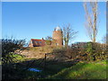
Photos: (1) Howes (a) derelict with 2 sails and broken stocks (2) NMR (a-f) derelict with 2 sails and broken stocks (g-j) as house converted (3) A C Smith (WIB) (a) house-converted tower, May 1972 (4) UOK (MC) (a-b) derelict with 2 sails and half of stock of other pair, August 1936

[Listed Building]

[Search Muggeridge Collection]


[Windmills] [Watermills] [Bookshop] [News] [Site map] :

Last updated 25/05/2011 Text and images © Mark Berry, 1997-2011 -