Rattlesden
#2476
Search:
Google images eBay wikipedia YouTube

(
52.18744,
0.87745)
Map/aerial photo of the area around the mill
Hitchcock's Tower Mill:
tower mill
function:Corn mill
- conserved
[
photo]
Entry in Mills Archive database -
#2476 - Hitchcock's Tower Mill, Rattlesden
(has photos)

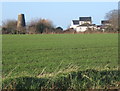
View across fields to disused windmill
[2008-01-05]
Andrew Hill

(1) Geograph images are licenced under a Creative Commons Attribution-Share Alike licence
Property details at Zoopla
Flickr images are copyright their individual photographers.
Images from Historic England - hover over image to see copyright info, and to enable zoom
Brettingham Road, Rattlesden, Mid Suffolk, Suffolk
12 May 2005 - Photograph (Digital)
