
Search: Google images eBay wikipedia YouTube
Town Mills:
[info] [painting]Search: Google images eBay wikipedia YouTube
Search: Google images eBay wikipedia YouTube
NGR: SU559168Chase Mills:
Search: Google images eBay wikipedia YouTube
NGR: SU516131Search: Google images eBay wikipedia YouTube
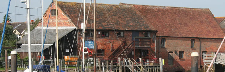
NGR: SZ414868Lower Mill: Watermill function:Corn mill
[info] [info] [info] [photo] [photo] [photo] [photo] [photo]Entry in Mills Archive database - #7549 - Lower Mill, Calbourne
This mill had a water turbine.
Search: Google images eBay wikipedia YouTube
NGR: SU365125Tide Mill:
Tide mill function:Corn mill
-
Entry in Mills Archive database - #6665 - Eling Tide Mill, Eling (has photos) Heritage Partner
Eling is one of only 8 tide mills (only two of which are working) that survive around the coast of the UK. They work with the rise and fall of the tides. A dam is created with a sluice across a tidal inlet; the tide comes in and enters the mill pond through a one way gate which closes automatically when the tide begins to fall. When the tide is low enough, the stored water can be released to turn a water wheel.
Grain for Eling in the old days would have been brought several hundred miles round the coast in barges from the Eastern side of England. When the tide was in, the barges could be sailed up Southampton Water, into Eling Creek, and right up to the Mill. Maximum possible output, running both waterwheels and all four sets of stones at full speed for both tides, would have been about 4 tonnes of flour per day.
The mill has always had two undershot waterwheels each one capable of running two pairs of millstones. The waterwheels originally were wooden, replaced in 1892 by cast iron ones along with the wheel shafts and gears.
The Grade II* Listed mill worked until the machinery broke down in 1936, after which the mill ran by diesel engine running the animal feed machinery. The mill was abandoned in 1946 and left to the elements until 1975 when it was bought by the New Forest District Council. They took on the job of repairing the mill which was in danger of collapsing. In 1980 The Eling Tide Mill Trust was responsible for overseeing the final stages of the repair and the re opening of the mill and museum. Since January 2009 Totton and Eling Town Council manage the mill.
Today the tide mill, surrounding riverside walks and adjacent visitor centre and cafe form The Eling Tide Mill Experience.
A partnership of New Forest District Council (NFDC) and Totton and Eling Town Council invested in its future after securing a grant from the Heritage Lottery Fund, which included work on all four parts of The Eling Tide Mill Experience. This included essential conservation works of the mill, extending and developing the visitor centre to create a new learning centre and café, and improving access to our outdoor areas of Goatee Beach and Bartley Water. The works were completed allowing the Eling Tide Mill Experience to reopen on 9th April 2018.
Visitors can now enjoy the mill and watch the power of the tide turning our machinery; explore the Discovery Room and get hands on with interactive displays and learn about the history of the mill; stroll along the fully accessible board walks and pathways; and enjoy our mill café and sample some products made with our flour.
Search: Google images eBay wikipedia YouTube
NGR: SU486293City Mill:
[info] [info] [info] [photo]Search: Google images eBay wikipedia YouTube
Yafford Mill: Watermill function:Corn mill
Entry in Mills Archive database - #7554 - Yafford Mill, Yafford (has photos)
The mill is Grade II Listed and used to be open to the public but it is now a private house. The overshot wheel still works, however it no longer grinds animal feed. The water source rises at a spring in Shorwell and runs in the English Channel at Grange Chine.
Search: Google images eBay wikipedia YouTube
tide mill function:Corn mill
[info] [photo]Entry in Mills Archive database - #7545 - Tide mill, Yarmouth
| Last generated 30/06/2026 | Text and images © Mark Berry, 1997-2026 - |
 (
(
