Thornton le Clay
#1161
Search:
Google images eBay wikipedia YouTube

(
54.08157,
-0.9667)
Map/aerial photo of the area around the mill
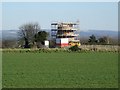
Tower mill function:Corn mill
Entry in Mills Archive database -
#1161 - Tower mill, Thornton le Clay

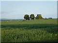
Cornfields and former Windmill in the distance
[2012-07-11]
- HD
Martin Dawes

(4) Geograph images are licenced under a Creative Commons Attribution-Share Alike licence
Flickr images are copyright their individual photographers.
