
Search: Google images eBay wikipedia YouTube
NGR: SP387128Tower mill function:Corn mill
-
Entry in Mills Archive database - #1619 - Tower mill, North Leigh
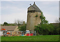
In 1907 this tower mill was apparently in working order, with four sweeps. It was built of stone, and the lower part of the mill was ivy-clad. The mill must have deteriorated, and was then restored to a working state in the 1930s. It was again in a dilapidated state by 1979. The mill had common sails, and weathering was achieved using an outside wooden screw and hand chain.
 (colour slide)
 (colour slide)
 (colour slide)
 (W B Muggeridge plate glass negative)
| International Mill Database Entry | |
|---|---|
| name | |
| id | 59494 |
| description | |
| drive power recent | |
| drive power originally | |
| mill type | |
| function type | |
| condition type | |
| map location | 51.8136,-1.440655 |
| country | |
| state | |
| county | |
| municipality | |
| city | |
| zip | |
| street | |
| logo detail | |
| Last generated 30/06/2026 | Text and images © Mark Berry, 1997-2026 - |
 (
(
