Stokesby
#2219
Search:
Google images eBay wikipedia YouTube
NGR:
TG422104

(
52.63766,
1.57893)
Map/aerial photo of the area around the mill
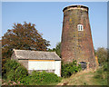
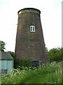
Commission Mill:
tower mill
(drainage)
[Search Muggeridge Collection]
Entry in Mills Archive database - #2219
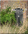
Stokesby Commission Mill - the door into the mill
[2009-09-19]
Evelyn Simak


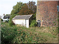
Commission Mill and adjoining cottage
[2009-09-19]
Evelyn Simak
Geograph images are licenced under a Creative Commons Attribution-Share Alike licence
Images from Historic England - hover over image to see copyright info, and to enable zoom
Stokesby With Herringby, Great Yarmouth, Norfolk
13 Sep 2007 - Photograph (Digital)


