Halvergate
#2237
Search:
Google images eBay wikipedia YouTube
NGR:
TG457072

(
52.60661,
1.62778)
Map/aerial photo of the area around the mill
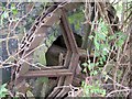
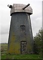
High's Mill:
tower mill
(drainage)
[Search Muggeridge Collection]
Entry in Mills Archive database - #2237
[
PastScape]
Geograph images are licenced under a Creative Commons Attribution-Share Alike licence
Images from Historic England - hover over image to see copyright info, and to enable zoom
Halvergate, Broadland, Norfolk
16 Oct 2005 - Photograph (Digital)

