Harston
#2339
Search:
Google images eBay wikipedia YouTube
NGR:
TL433502

(
52.13110,
0.09088)
Map/aerial photo of the area around the mill
tower mill
function:Corn mill
- truncated
Entry in Mills Archive database -
#2339 - Tower mill, Harston
Muggeridge Collection photos
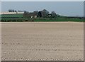
Over fields to The Old Windmill
[2012-03-29]
- HD
John Sutton

(1) Geograph images are licenced under a Creative Commons Attribution-Share Alike licence
tower millPhotos: (1) NMR (a) surviving base (2) A C Smith (WIC) (a) surviving base, May 1972 (3) CCL (a) w/o (4) UOK (MC) (a) sur-viving base, June 1935
|
International Mill Database Entry |
|---|
| name |
Harston Windmill |
| id |
59636 |
| description |
Disused tower mill, truncated and without any technique |
| drive power recent |
none |
| drive power originally |
windmill |
| mill type |
tower mill |
| function type |
grain mill |
| condition type |
abandoned |
| map location |
52.13109,0.0909 |
| country |
United Kingdom |
| state |
England |
| county |
Cambridgeshire |
| municipality |
Cambridge |
| city |
Harston |
| street |
Newton Road |
| logo detail |
windmill_nophoto |

