Top Growland's Mill, Easton, Isle of Portland, Dorset 🌍


Easton, Isle of Portland #235

Search: Google images eBay wikipedia YouTube
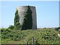
NGR: SY692713
(50.54059,-2.4362)


Map/aerial photo of the area around the mill

Top Growland's Mill: tower - cylindrical stone tower

[info] [photo] [photo] [photo] [info]

[Search Muggeridge Collection]

Entry in Mills Archive database - #235

[English Heritage]

Ruined windmill near Weston [2010-06-25]

David Smith

Geograph images are licenced under a Creative Commons Attribution-Share Alike licence

[Listed Building]

Flickr images are copyright their individual photographers.
Images from Historic England - hover over image to see copyright info, and to enable zoom
A view towards Droop Field Windmill
Droop Field Windmill, Portland, Easton, Weymouth And Portland, Dorset
Jul 1961 - Photograph (Negative)
Exterior view of the windmill from a distance
South Windmill, Portland, Easton, Weymouth And Portland, Dorset
22 Oct 1962 - Photograph (Acetate Negative)
Windmill About 980 Yards South East Of St Georges Reforne / Windmill At Ngr Sy 69077128
Windmill About 980 Yards South East Of St Georges Reforne, Portland, Weymouth And Portland, Dorset
27 Jun 2001 - Photograph (Digital)
From the Images of England project


[Windmills] [Watermills] [Bookshop] [News] :

Last updated 16/09/2025 Text and images © Mark Berry, 1997-2025 -