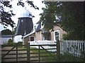
Drinkstone
#2472
Search:
Google images eBay wikipedia YouTube

(
52.22201,
0.87411)
Map/aerial photo of the area around the mill
smock mill
function:Corn mill
- conserved
Opening times - WARNING : may not be up to date
| opening times |
charges |
website |
notes |
| Has opened previously, but current opening plans unknown |
|
No known website providing opening details |
|
[
Drinkstone mills - dedicated page]
Entry in Mills Archive database -
#2472 - Smock mill, Drinkstone
Muggeridge Collection photos
[
PastScape]
(2) Geograph images are licenced under a Creative Commons Attribution-Share Alike licence
Wikipedia entry
Property details at Zoopla
Flickr images are copyright their individual photographers.
Images from Historic England - hover over image to see copyright info, and to enable zoom
Drinkstone Smock Mill, Drinkstone, Mid Suffolk, Suffolk
7 Jun 1951 - Photograph (Negative)
Smock Mill, 20 Metres North Of Mill Cottage (Including Attached Engine Shed And Oil Engine), Woolpit Road, Drinkstone, Mid Suffolk, Suffolk
22 Aug 2002 - Photograph (Digital)

 (colour slide)
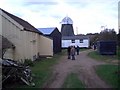
