Luddenham
#2748
Search:
Google images eBay wikipedia YouTube

(
51.32647,
0.88259)
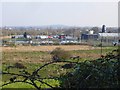
Map/aerial photo of the area around the mill
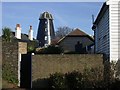
Tower mill function:Corn mill
- house converted

Luddenham, 1986 © Rob Cumming
Entry in Mills Archive database -
#2748 - Oare Mill, Luddenham
Muggeridge Collection photos
[
PastScape]
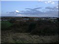
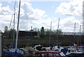
View from Church Road, looking across the creek
[2007-12-01]
pam fray

(4) Geograph images are licenced under a Creative Commons Attribution-Share Alike licence
Property details at Zoopla
Flickr images are copyright their individual photographers.
1 Facebook posts and images
for information on Oare Mill, Luddenham
Images from Historic England - hover over image to see copyright info, and to enable zoom
Oare Road, Faversham, Swale, Kent, ME13 7TJ
23 Feb 2002 - Photograph (Digital)
Oare Windmill, Oare Road, Faversham, Swale, Kent
19 Oct 1930 - Photograph (Nitrate Negative)
Oare Windmill, Oare Road, Faversham, Swale, Kent
19 Oct 1930 - Photograph (Nitrate Negative)


