
Search: Google images eBay wikipedia YouTube
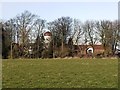
NGR: NZ129695tower mill - Appears to have been demolished about 2020 (even though it was a listed building!)
A folly - a watertower built in c1927, but designed to look like a former windmill. Shown as a windmill on some OS maps.
| Last updated 06/05/2026 | Text and images © Mark Berry, 1997-2026 - |
 (
(

