
Melin Wynt Mynydd Parys Windmill
[1997-11-03]
- HD
Eric Jones


Modern wind turbine viewed from a door in the derelict windmill on Parys Mountain
[1997-11-03]
- HD
Eric Jones

Windmill and Trig Point on the summit of Mynydd Parys
[1997-11-03]
- HD
Eric Jones
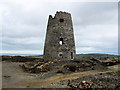
Old Windmill on Parys Mountain
[2014-04-04]
- HD
Chris Heaton

Inside of the old windmill tower, Parys Mountain
[2009-09-17]
Dave Croker

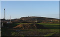
View across pastureland and coverts towards Mynydd Parys
[2009-01-17]
Eric Jones

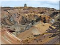
Twll Mawr and the summit windmill
[2009-01-17]
Eric Jones

Waste tips below the summit of Mynydd Parys
[2009-01-17]
Eric Jones
View west across farmland towards Parys Mountain
[2009-01-17]
Eric Jones
(16) Geograph images are licenced under a Creative Commons Attribution-Share Alike licence

 (
(


