Search: Google images eBay wikipedia YouTube
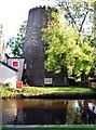
tower mill function:Corn mill 1810 - converted - used as shops and art gallery
Entry in Mills Archive database - #1092 - Tower mill, Parbold
The Old Windmill, Parbold [2026-04-08] - HD
Stephen McKay
Mill House Gallery & Framing Studio, Parbold [2026-04-08] - HD
The Windmill, Parbold [2026-04-08] - HD
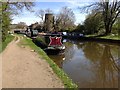
Leeds & Liverpool Canal, Parbold [2026-04-08] - HD
The Leeds and Liverpool Canal at Parbold [2013-05-02] - HD
Ian Greig
The Mill House Gallery, Mill Lane, Parbold. [2011-10-21]
Alexander P Kapp
Parbold Mill [2011-07-01] - HD
philandju
Parbold windmill. [2009-09-10] - HD
Chris Denny
Parbold Windmill [1992-00-00]
Gareth Hughes
Frozen canal - Parbold [2007-02-07]
Dave Green
Parbold [2004-09-18]
Sue Adair

 (
(


