Fulford
#1273
Search:
Google images eBay wikipedia YouTube

(
52.95789,
-2.1061)
Map/aerial photo of the area around the mill
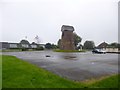
Meir Heath:
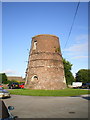
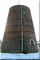
tower mill
function:Corn mill
- flat roofed tower, recently made watertight
Opening times - WARNING : may not be up to date
| opening times |
charges |
website |
notes |
| Has opened previously, but current opening plans unknown |
|
No known website providing opening details |
|
[
homepage]
[
info]
[
info]
[
photo]
Entry in Mills Archive database -
#1273 - Tower mill, Meir Heath
Muggeridge Collection photos
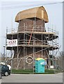
Meir Heath Windmill restoration
[2010-04-10]
John M

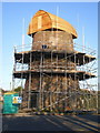
Restoration work underway on the Meir Heath windmill
[2010-03-09]
- HD
Richard Law
(6) Geograph images are licenced under a Creative Commons Attribution-Share Alike licence
Associated charity
#1115772
- Meir Health Windmill Preservation Group
blipfoto images are copyright their individual photographers.
Flickr images are copyright their individual photographers.
1 Facebook posts and images
for information on Tower mill, Meir Heath
Images from Historic England - hover over image to see copyright info, and to enable zoom
Hilderstone Road, Fulford, Stafford, Staffordshire, ST3 7PB
9 Jul 2003 - Photograph (Digital)

 (colour slide)
 (colour slide)
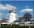