
| # | photo | id | name | location | type | condition | maps |
|---|---|---|---|---|---|---|---|
| 1 |
no image |
#1275 | Werrington | Caverswall | tower mill | now houses radio communications |
(53.02483,-2.0879)
|
| 2 |
no image |
#1270 | Codsall | tower mill | House converted |
(52.63467,-2.1983)
|
|
| 3 | 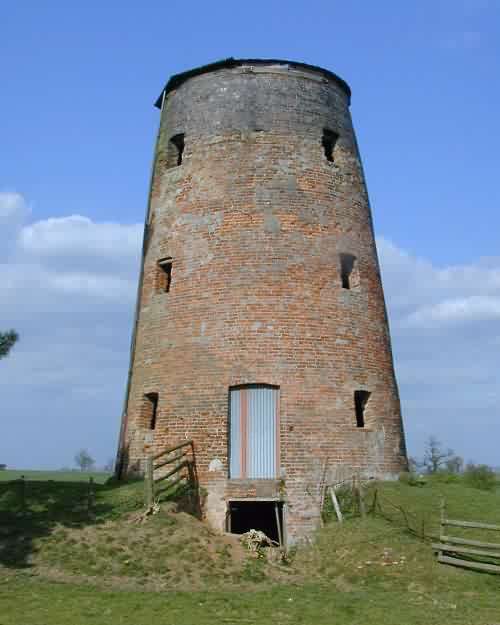 |
#1271 | Butterhill | Coppenhall | tower mill | derelict |
(52.76944,-2.1527)
|
| 4 | 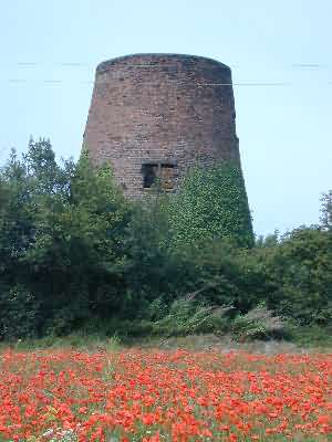 |
#1264 | Croxton | Eccleshall | tower mill | Recently house converted |
(52.88384,-2.3255)
|
| 5 |
no image |
#1568 | Spittlebrook Windmill | Enville | tower mill | derelict |
(52.48668,-2.2294)
|
| 6 |
no image |
#1276 | Essington | post mill | roundhouse and main post remain, derelict |
(52.63088,-2.0848)
|
|
| 7 | 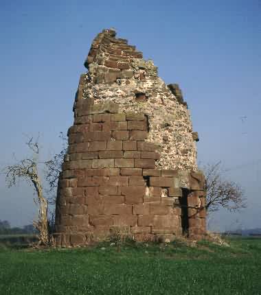 |
#1263 | Forton | tower mill | incorporated into a monument/folly c1780, now ruined |
(52.79203,-2.3592)
|
|
| 8 |
no image |
#1273 | Meir Heath | Fulford | tower mill | flat roofed tower, recently made watertight |
(52.95789,-2.1061)
|
| 9 |
no image |
#1278 | Gentleshaw Mill | Gentleshaw | tower mill |
(52.70458,-1.9262)
|
|
| 10 |  |
#1266 | Beffcote | Gnosall | tower mill | house converted |
(52.77279,-2.2932)
|
| 11 |
no image |
#1279 | Speedwell Mill | Hammerwich | tower mill | house converted |
(52.66413,-1.9017)
|
| 12 | 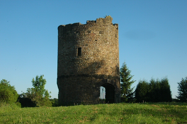 |
#1269 | Long Row Mill | Kidsgrove | tower mill |
(53.08355,-2.2399)
|
|
| 13 |
no image |
#1281 | Grange Lane Mill | Lichfield | tower mill | house converted |
(52.69250,-1.8400)
|
| 14 |
no image |
#1567 | Nurton Hill Mill | Pattingham | tower mill | house converted |
(52.59621,-2.2436)
(approximate location)
|
| 15 |  |
#1277 | Shareshill Mill | Saredon | tower mill | house converted, painted pink |
(52.66232,-2.0772)
|
| 16 |
no image |
#1272 | Broad Eye | Stafford | tower mill | Conserved - being adapted as an Industrial Heritage Museum |
(52.80683,-2.1228)
|
| 17 |  |
#1280 | Brereton Cross Windmill|Upper Longdon Mill | Upper Longdon | tower mill | house converted |
(52.73134,-1.9026)
|
| 18 |
no image |
#1282 | Weeford Mill | Weeford | tower mill |
(52.61583,-1.8026)
|
This table is selective, and probably far from comprehensive.
| # | photo | id | name | location | type | condition | maps |
|---|---|---|---|---|---|---|---|
| 1 |
no image |
DetailsAris's Birmingham Gazette, 26 January 1784 TO be LET and entered upon immediately, An exceedingly well-blown Windmill, in which there are two good Pair of Stones, one French, the other English, and every other Convenience thereto belonging, situate near the populous Town of Bilston, in the County of Stafford, and within two Hundred Yards of the Canal; nine Miles from Birmingham, two Miles of Wolverhampton, and four of Dudley, which said Mill was late in the Holding of Messrs. Chapman and Brown.- For further Particulars apply to Mr. Offley, at the Clive, near Pattingham, or of Mr. Brown, of the Wood Farm, near Sedgley. |
| Last generated 30/06/2026 | Text and images © Mark Berry, 1997-2026 - Some images © Mike Matthews |
 (
(