
Search: Google images eBay wikipedia YouTube
Brereton Cross Windmill|Upper Longdon Mill:
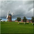
tower mill
function:Corn mill
-
In 2014/15, a previous and largely unsympathetic house conversion has been removed, and new works done proving a more authentic appearance, including new cap and fantail.


Entry in Mills Archive database - #1280 - Windmill Farm Mill, Upper Longdon
| Last generated 30/06/2026 | Text and images © Mark Berry, 1997-2026 - |
 (
(


