Enville
#1568
Search:
Google images eBay wikipedia YouTube

(
52.48668,
-2.2294)
Map/aerial photo of the area around the mill
Spittlebrook Windmill:
tower mill
function:Corn mill
- derelict
[
info]
[
info]
[
history]
Entry in Mills Archive database -
#1568 - Tower mill, Enville
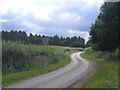
Winding lane beside the old windmill
[2008-07-03]
Row17

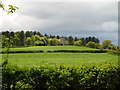
Old Windmill, Kinver Million
[2005-05-08]
Martyn B
(2) Geograph images are licenced under a Creative Commons Attribution-Share Alike licence
Images from Historic England - hover over image to see copyright info, and to enable zoom
Mill Lane, Kinver, South Staffordshire, Staffordshire
16 May 2004 - Photograph (Digital)
