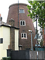
Plumstead
#2638
Search:
Google images eBay wikipedia YouTube
NGR:
TQ448779

(
51.48171,
0.08410)
Map/aerial photo of the area around the mill
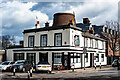
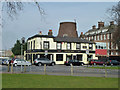
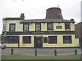
Common Mill:
Tower mill function:Corn mill
- converted, providing accommodation above the Old Mill pub

Plumstead, 10th Feb 2007

Plumstead, 10th Feb 2007
[
photo]
[
photo]
Entry in Mills Archive database -
#2638 - Common Mill, Plumstead
(has photos)

[
London Picture Archive]
[
London Picture Archive]
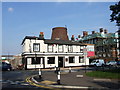
Plumstead : "The Old Mill" public house
[2022-02-24]
- HD
Jim Osley

(5) Geograph images are licenced under a Creative Commons Attribution-Share Alike licence
[StreetView]
Flickr images are copyright their individual photographers.
Images from Historic England - hover over image to see copyright info, and to enable zoom
Old Mill Road Se18, Woolwich, Greenwich, Greater London, SE18 1QG
30 Mar 2004 - Photograph (Digital)
|
International Mill Database Entry |
|---|
| name |
Plumstead Common Windmill |
| id |
15666 |
| description |
Converted tower mill |
| drive power recent |
none |
| drive power originally |
windmill |
| mill type |
tower mill |
| function type |
grain mill |
| condition type |
no technique |
| use today |
café |
| map location |
51.481740,0.084140 |
| country |
United Kingdom |
| state |
England |
| county |
Greater London |
| municipality |
London |
| city |
Greenwich |
| city part |
Plumstead |
| zip |
SE18 1QG |
| street |
Old Mill Rd 1 |
| logo detail |
windmill_nophoto |
