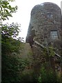
Carluke windmill,
Scotland
🌍
Carluke
(#scot10)
Search:
Google
images
eBay
wikipedia
YouTube
NGR:
NS849508
(
55.73670
,
-3.8341
)
Google Maps
,
OpenStreetMap
Bing
Google Earth (web)
geograph
GeoHack
Nearby Photos
Map/aerial photo of the area around the mill
tower mill
The High Mill [2009-07-20] - HD
Jim Ness
(1) Geograph images are licenced under a Creative Commons Attribution-Share Alike licence
News item:
Carluke windmill, Scotland, in partial collapse
(4/3/03)
[
Windmills
] [
Watermills
] [
Bookshop
] [
News
] :
Last updated 06/05/2026
Text and images © Mark Berry, 1997-2026 -

 (
(
