| # |
photo |
id |
name |
location |
maps |
type |
condition |
| 1 |
no
image
|
#1664
|
Nixey's Mill |
BrillBuckinghamshireUKBrill
|
NGR:
SP652142

( 51.82207, -1.0553)
|
post |
Preserved - unable to turn to face wind.
Extensively restored in 2009, giving it a new external appearance with new roundhouse, rear steps,
weatherboarding and sails.
|
| 2 |
no
image
|
#1704
|
Caldecotte Arms Mill |
Caldecotte - Milton KeynesBuckinghamshireUKCaldecotte - Milton Keynes
|
NGR:
SP887355

( 52.01098, -0.7078)
|
tower |
built as a dummy mill (by professional millwrights) for pub/hotel complex |
| 3 |
no
image
|
#1711
|
Hawridge |
CholesburyBuckinghamshireUKCholesbury
|
NGR:
SP935069

( 51.75312, -0.6466)
|
tower |
built on site of previous smock mill |
| 4 |
no
image
|
#1833
|
Grove's Mill |
ColeshillBuckinghamshireUKColeshill
|
NGR:
SU948948

( 51.64412, -0.6307)
|
tower |
house converted |
| 5 |
no
image
|
#1719
|
|
EdlesboroughBuckinghamshireUKEdlesborough
|
NGR:
SP982192

( 51.86246, -0.5748)
|
tower |
(alongside watermill) - house converted |
| 6 |
 |
#1819
|
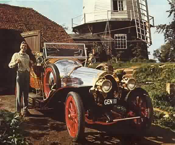
Cobstone Mill |
IbstoneBuckinghamshireUKIbstone
|
NGR:
SU769915

( 51.61701, -0.8895)
|
smock |
cosmetically restored for a starring part in "Chitty Chitty Bang Bang".
|
| 7 |
no
image
|
#1695
|
|
Lacey GreenBuckinghamshireUKLacey Green
|
NGR:
SP819008

( 51.69979, -0.8160)
|
smock |
conserved |
| 8 |
no
image
|
#1696
|
|
New Bradwell - Milton KeynesBuckinghamshireUKNew Bradwell - Milton Keynes
|
NGR:
SP831411

( 52.06225, -0.7891)
|
tower |
restored |
| 9 |
no
image
|
#1690
|
|
North MarstonBuckinghamshireUKNorth Marston
|
NGR:
SP775228

( 51.89825, -0.8751)
|
tower |
truncated |
| 10 |
 |
#1713
|
|
PitstoneBuckinghamshireUKPitstone
|
NGR:
SP945157

( 51.83176, -0.6298)
|
post |
conserved, owned by the National Trust |
| 11 |
no
image
|
#1681
|
|
QuaintonBuckinghamshireUKQuainton
|
NGR:
SP746203

( 51.87556, -0.9167)
|
tower |
restored to working order |
| 12 |
no
image
|
#1679
|
|
ThornboroughBuckinghamshireUKThornborough
|
NGR:
SP737352

( 52.01055, -0.9271)
|
tower |
truncated |
| 13 |
no
image
|
#1702
|
|
WendoverBuckinghamshireUKWendover
|
NGR:
SP873082

( 51.76571, -0.7450)
|
tower |
house converted |
| 14 |
no
image
|
#1838
|
|
WexhamBuckinghamshireUKWexham
|
NGR:
SU995844

( 51.55027, -0.5661)
|
tower |
truncated and converted |
This table is selective, and probably far from comprehensive.
| # |
photo |
id |
name |
location |
maps |
type |
condition |
| 1 |
no
image
|
#1832
|
|
BeaconsfieldBuckinghamshireUKBeaconsfield
|
NGR:
SU948901

( 51.60085, -0.6314)
(approximate location)
|
tower |
|
| 2 |
no
image
|
#1821
|
|
Bledlow RidgeBuckinghamshireUKBledlow Ridge
|
NGR:
SU799979

( 51.67328, -0.8446)
(approximate location)
|
post |
had 3 cross trees, and 6 quarterbars |
| 3 |
no
image
|
#8798
|
Parsons Mill |
BrillBuckinghamshireUKBrill
|
|
post mill
|
demolished 1906 |
| 4 |
no
image
|
|
|
Cholesbury |
|
smock |
demolished 1884 |
| 5 |
no
image
|
#1677
|
|
CuddingtonBuckinghamshireUKCuddington
|
NGR:
SP730109

( 51.79110, -0.9416)
(approximate location)
|
post |
|
| 6 |
no
image
|
#1688
|
|
Great HorwoodBuckinghamshireUKGreat Horwood
|
NGR:
SP765299

( 51.96147, -0.8867)
(approximate location)
|
tower |
|
| 7 |
no
image
|
#1699
|
|
Great LinfordBuckinghamshireUKGreat Linford
|
NGR:
SP850420

( 52.06903, -0.7600)
(approximate location)
|
post mill
|
remains dated to 1220 |
| 8 |
no
image
|
#12398
|
Frith Hill |
Great Missenden |
|
smock |
|
| 9 |
no
image
|
#1678
|
|
HaddenhamBuckinghamshireUKHaddenham
|
NGR:
SP735090

( 51.77396, -0.9348)
(approximate location)
|
tower |
demolished 1930's |
| 10 |
no
image
|
#12397
|
|
Haddenham |
|
post |
|
| 11 |
no
image
|
#1670
|
Manor Farm mill |
HillesdenBuckinghamshireUKHillesden
|
NGR:
SP675282

( 51.94735, -1.0180)
(approximate location)
|
strange "home made" mill |
partly demolished 1930's |
| 12 |
no
image
|
#1829
|
Holmer Green Windmill |
Little MissendenBuckinghamshireUKLittle Missenden
|
NGR:
SU900970

( 51.66367, -0.6989)
(approximate location)
|
tower |
|
| 13 |
no
image
|
#1673
|
|
Long CrendonBuckinghamshireUKLong Crendon
|
NGR:
SP693093

( 51.77719, -0.9956)
(approximate location)
|
post |
demolished 1931 |
| 14 |
no
image
|
#1674
|
|
Long CrendonBuckinghamshireUKLong Crendon
|
NGR:
SP693097

( 51.78078, -0.9955)
(approximate location)
|
tower |
demolished 1925 |
| 15 |
no
image
|
#12275
|
|
Stantonbury |
|
tower |
|
| 16 |
no
image
|
#1700
|
|
StewkleyBuckinghamshireUKStewkley
|
NGR:
SP855253

( 51.91881, -0.7569)
(approximate location)
|
smock |
|
| 17 |
no
image
|
#1818
|
|
StokenchurchBerkshireUKStokenchurch
|
NGR:
SU751966

( 51.66225, -0.9143)
(approximate location)
|
post |
collapsed 1935 |
| 18 |
no
image
|
#1691
|
|
StoneBuckinghamshireUKStone
|
NGR:
SP779123

( 51.80303, -0.8703)
(approximate location)
|
post |
|
| 19 |
no
image
|
#1665
|
|
TwyfordBuckinghamshireUKTwyford
|
NGR:
SP654271

( 51.93771, -1.0487)
(approximate location)
|
tower |
|
| 20 |
no
image
|
#1684
|
|
WaddesdonBuckinghamshireUKWaddesdon
|
NGR:
SP752168

( 51.84386, -0.9085)
(approximate location)
|
tower |
|


 (
(