
| # | photo | id | name | location | type | condition | maps |
|---|---|---|---|---|---|---|---|
| 1 |
no image |
#i9 | Ballinvella, Co Wexford | tower mill | short tower remains | ||
| 2 |
no image |
#i19 | Ballymackney, Co. Monaghan | tower mill | bare tower |
(53.96017,-6.6569)
|
|
| 3 |
no image |
#i18 | Balrath, Co. Meath | tower mill | recently house converted |
(53.62334,-6.4806)
|
|
| 4 |
no image |
#i13 | Bartramstown, Co. Meath | tower mill | derelict empty tower |
(53.59341,-6.3779)
|
|
| 5 |
no image |
#i2 | Blennerville | tower mill | restored to working order - open to the public |
(52.25669,-9.7373)
|
|
| 6 |
no image |
#i22 | Carnanbregagh, Dundalk | tower mill | ivy covered |
(53.97919,-6.4246)
|
|
| 7 |
no image |
#i28 | Carrivetragh, Co. Monaghan | tower mill |
(54.20784,-7.2295)
|
||
| 8 |
no image |
#i16 | Christians Hill, Ardee, Co. Louth | tower mill | ruin |
(53.87071,-6.5230)
|
|
| 9 |
no image |
#i23 | Cloghan Beg, Co. Offaly | tower mill | ruin |
(53.16815,-8.0224)
|
|
| 10 |
no image |
#i27 | Corballis, Co. Meath | tower mill | ruin |
(53.67135,-6.2566)
|
|
| 11 |
no image |
#i25 | Croan, Co. Kilkenny | tower mill |
(52.47739,-7.2683)
|
||
| 12 |
no image |
#i31 | Croghan Hill, Co Donegal | tower mill | |||
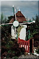
| 13 |  |
#i1 | St Patricks Tower | Dublin | tower mill | capped tower stands within the Guinness factory complex |
(53.34402,-6.2840)
|
| 14 |
no image |
#i8 | Seatown mill | Dundalk | tower mill | seven storey high bare unroofed tower |
(54.00583,-6.3891)
|
| 15 |
no image |
#i5 | Elphin, Co Roscommon | tower mill | restored in 1996, a vertically sided thatched mill, with tailpole to turn the 4 common sails into the wind |
NGR:
M862893
(53.85188,-8.2053)
|
|
| 16 |
no image |
#i36 | Enagh, Co Caven | tower mill |
(53.85654,-7.0492)
|
||
| 17 |
no image |
#i7 | Vinegar Hill | Enniscorthy | tower mill | empty stump remains |
(52.50147,-6.5532)
|
| 18 |
no image |
#i35 | Fordrath, Co. Meath | tower mill | ruin |
(53.62356,-6.8892)
|
|
| 19 |
no image |
#i17 | Garristown, Co. Dublin | tower mill | bare tower |
(53.56361,-6.3933)
|
|
| 20 |
no image |
#i10 | Hook Peninsular, Wexford | tower mill | ruinous | ||
| 21 |
no image |
#i29 | Libgate, Wexford | tower mill |
(52.18522,-6.5718)
|
||
| 22 |
no image |
#i11 | Lobinroe | tower mill | unroofed bare tower | NGR: M872524 | |
| 23 |
no image |
#i21 | Mullanour, Wexford | tower mill | bare tower |
(52.31187,-6.5340)
|
|
| 24 |
no image |
#i24 | Pepperstown, Co. Louth | tower mill |
(53.88751,-6.5315)
|
||
| 25 |
no image |
#i15 | Piperstown, Co. Louth | tower mill | bare tower |
(53.78319,-6.3398)
|
|
| 26 |  |
#i4 | Skerries, Co. Dublin | tower mill | 4 sailed thatched tower mill |
(53.57458,-6.1130)
|
|
| 27 |  |
#i3 | The Great Windmill | Skerries, Co. Dublin | tower mill | fully restored, 5 sails, wheeled tailpole |
(53.57506,-6.1101)
|
| 28 |
no image |
#i32 | St. Margaret's, Co. Dublin | tower mill |
(53.43346,-6.2932)
|
||
| 29 |
no image |
#i12 | Stameen, Co. Meath | tower mill | derelict, 3 storey cylindrical tower |
NGR:
O12547538
(53.71594,-6.2965)
|
|
| 30 |
no image |
#i6 | Tacumshane, Co. Wexford | tower mill | complete, restored mill, with thatched roof |
(52.20877,-6.4244)
|
|
| 31 |
no image |
#i30 | Yola Farmstead and Folk Park | Tagoat, Rosslare Harbour, Co. Wexford | tower mill |
(52.24533,-6.3838)
|
|
| 32 |
no image |
#i26 | Termonfeckin, Co. Louth | tower mill |
(53.76712,-6.2703)
|
||
| 33 |
no image |
#i20 | Whitemill, Co. Louth | tower mill | ruin |
(54.04463,-6.3947)
|
Search: Google images eBay wikipedia YouTube
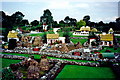
Larry's Old Time Village:
| Last generated 30/06/2026 | Text and images © Mark Berry, 1997-2026 - |
 (
(
